Region 3 Trinity Flood Planning Region
Originating in North Central Texas in a highly urbanized watershed, the Trinity River and its many tributaries meander southeast on their way south to the Gulf of Mexico. The lower reaches of the Trinity River cross through Davy Crockett and Sam Houston National Forests before entering Trinity Bay just north of Galveston. Smaller streams within the basin include the Clear, East, Elm, and West forks of the Trinity River and Cedar, Chambers, and Richland creeks. There are 34 major lakes and reservoirs in Region 3.

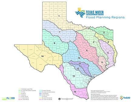
Flood Planning Region Boundaries Map
The TWDB designated 15 flood planning regions statewide on April 9, 2020. Board designation of flood planning regions is required under Senate Bill 8, 86th Texas Legislature, which established a new regional and state flood planning process for the state.
Facts and Figures about the Trinity Flood Planning Region (Region 3)
Population Estimate (2019): 8 million
Approximate Area: 18,000 square miles
Approximate Stream Miles: 47,000
Approximate NFIP Claims (1975-2019): $225,261,554
Counties Represented:
- Anderson*
- Archer*
- Chambers*
- Clay*
- Collin*
- Cooke*
- Dallas
- Denton
- Ellis
- Fannin*
- Freestone*
- Grayson*
- Grimes*
- Hardin*
- Henderson*
- Hill*
- Hood*
- Houston*
- Hunt*
- Jack*
- Johnson*
- Kaufman*
- Leon*
- Liberty*
- Limestone*
- Madison*
- Montague*
- Navarro
- Parker*
- Polk*
- Rockwall*
- San Jacinto*
- Tarrant
- Trinity*
- Van Zandt*
- Walker*
- Wise
- Young*
*indicates this county is partially within this RFPG and is also represented by at least one other RFPG
Major Cities (Population greater than 25,000):
- Allen
- Arlington
- Balch Springs
- Bedford
- Burleson
- Carrollton
- Cedar Hill
- Colleyville
- Coppell
- Dallas
- Denton
- DeSoto
- Duncanville
- Euless
- Farmers Branch
- Flower Mound
- Fort Worth
- Frisco
- Garland
- Grand Prairie
- Grapevine
- Haltom City
- Huntsville*
- Hurst
- Irving
- Keller
- Lancaster
- Lewisville
- Little Elm
- Mansfield
- McKinney
- Mesquite
- North Richland Hills
- Plano
- Richardson
- Rockwall
- Rowlett
- Sachse
- Southlake
- The Colony
- Waxahachie
- Weatherford*
- Wylie
*indicates this city is partially within this RFPG and is also represented by at least one other RFPG
Major Lakes & Reservoirs:
- Alders Reservoir
- Bardwell Lake
- Benbrook Lake
- Cedar Bayou Generating Pond
- Cedar Creek Reservoir Trinity
- Eagle Mountain Lake
- Fairfield Lake
- Forest Grove Reservoir
- Grapevine Lake
- Houston County Lake
- Joe Pool Lake
- Lake Amon G Carter
- Lake Anahuac
- Lake Arlington
- Lake Bridgeport
- Lake Halbert
- Lake Kiowa
- Lake Livingston
- Lake Ray Hubbard
- Lake Ray Roberts
- Lake Waxahachie
- Lake Weatherford
- Lake Worth
- Lavon Lake
- Lewisville Lake
- Lost Creek Reservoir
- Mountain Creek Lake
- Navarro Mills Lake
- New Terrell City Lake
- North Lake
- Richland-Chambers Reservoir
- Trinidad Lake
- Wallisville Lake
- White Rock Lake
Ecoregions of Texas Represented:
- Blackland Prairie
- Cross Timbers
- Gulf Prairies
- Piney Woods
- Post Oak Savanah
- Rolling Plains